The Sentinel Peak Hike takes you to the top of the Tugela Falls, which explains why it’s also known as the Tugela Falls Hike. You’ll be climbing up the Amphitheatre via the famous chain ladders, and looking out over its impressive valley floor, almost 1 km (~ 0.62 miles) below. Want to see this with your own eyes? Keep reading!
TIP: The locations in this article are clickable and will take you to the corresponding marker on the map. You can find the map on the right of your screen, or by clicking the map icon on the bottom if you’re on mobile.
Sentinel Peak Hike in short
- Duration? 12 km (~ 7.5 miles) or 6 hours
- Difficulty? challenging
- Decor? impressive mountain views, Tugela Falls, chain ladders
- When? best from March to April
- How much? R125 ~ $8.50 ~ €7.50 per person (no guide)
- Bring? waterproof jacket, charged phone, camera
- Where to stay? Amphitheatre Backpackers Lodge or Witsieshoek Mountain Lodge
Where is Tugela Falls?
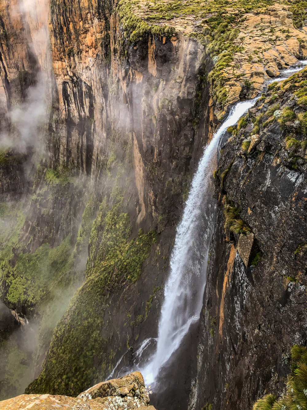
Tugela Falls is the world’s second highest waterfall, plunging a whopping 948 m (~ 3,110 ft) off of the Mont-Aux-Sources plateau into the valley below. It’s not 1 drop though, rather 5 leaps. Still impressive!

Side note: there’s discussion about the true height of the Tugela Falls. Recent measurements concluded on a 983 m (~ 3,225 ft) high waterfall. This would make Tugela Falls the tallest waterfall in the world, passing the 979 m (~ 3,211 ft) Angel Falls in Venezuela.
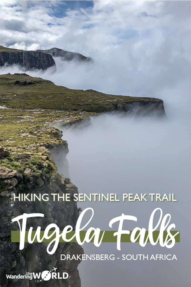
The monumental cliff face of the Mont-Aux-Sources plateau is called the Amphitheatre, because of the way it looks from the valley. Situated in Royal Natal National Park, South Africa, it sits on the border between the KwaZulu-Natal province and Lesotho. Phuthaditjhaba is the closest town.
This mountain range is part of the Drakensberg (Afrikaans for Dragon Mountain), the 1,000 km (~ 620 miles) long eastern part of the Great Escarpment. Amazing views on the Panorama Route, like the Three Rondavels, are part of the Drakensberg escarpment as well.
Did you know? Tugela Falls gets its name from the Zulu word “Thukela”, meaning “sudden”.
The Sentinel Peak Hike – practical information
To get to the top of this remarkable Tugela Waterfall, you have to hike the Sentinel Peak Hike, also known as the Tugela Falls Hike. It’s a Drakensberg day hike of about 12 km (~ 7.5 miles) round trip, which took us about 6 hours to complete. Don’t forget to take lunch, snacks and plenty of water!
How to get to the Sentinel Peak Hike?
Directions to get there by car
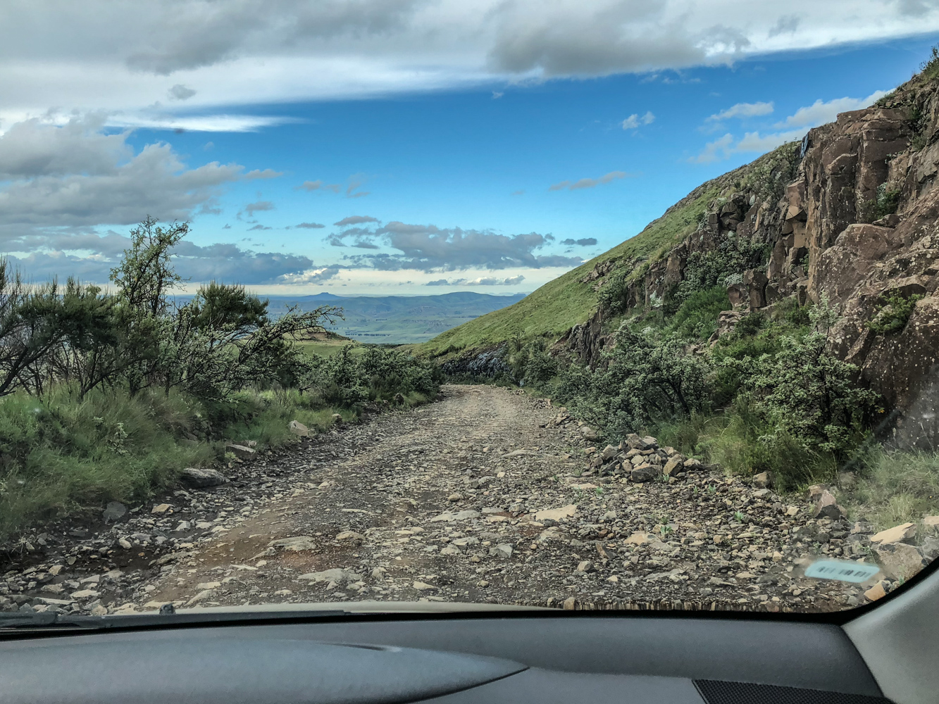
The Sentinel Peak Hike starts at the Sentinel Car Park, where we drove to in our rental car. Keep in mind that about 4.5 km (~ 2.8 miles) of the last part of the road to the car park is unsealed and in bad shape. After that there’s another 2.5 km of paved road.


It had been raining (and still rained) while we were driving up there. Parts of the soil had been washed away, leaving big rocks sticking out of the road. The first part is a pretty good indication of how the rest of the road will be, although it got slightly worse at certain points. If you’re not comfortable driving there, it’s better to turn around.
With our modest Toyota Etios Sprint rental it was a bit of a nerve-racking ride, but we did eventually make it there in one piece. We wouldn’t have done it with our own car though.
They were working on the car park facilities during our visit, so chances are this road will become sealed eventually. Do update us on the road condition in the comments if you visit yourself!
If you’re not willing to drive there yourself, you can go left to Witsieshoek Mountain Lodge instead of taking a right onto the unsealed road. You can ask for a ride to (and from) the Sentinel Car Park there. This will cost you R255 (~ $18 ~ €16) for a round trip if you’re alone, or R150 (~ $10 ~ €9) per person if you’re 2 or more.
In any case, keep your camera ready to snap some shots of the amazing views on the way up to the Sentinel Car Park.

Join a guided hike to Tugela Falls that includes transportation
If you don’t have a car at your disposal, you can book a guide with transportation or join a guided hike to Tugela Falls. Jump to the guided hike section of this post.
It’s possible your accommodation offers transfers to and from the Sentinel Car Park, the start of the hike, as well. Jump to the section about accommodation near the Tugela Falls.
What will the Sentinel Peak Hike cost you?
While driving up to the Sentinel Car Park, you will pass a check point. There, you have to pay a R50 (~ $3.50 ~ €3) fee per person, and write your information in a hiking register. That’s how they track if everyone that started the hike has returned.
At the Sentinel Car Park, the start of the hike, you have to pay another R75 (~ $5 ~ €4.5) per person and sign another hiking register. We got a map of the Sentinel Peak Hike as well, with emergency numbers on it.
Drakensberg weather conditions
The weather conditions can change quickly, like every hour, at Drakensberg, so you can’t really rely on forecasts. Instead, be prepared for anything when starting the Sentinel Peak Hike.
When we did the hike, it had been raining for a couple of days. On the morning of our hike it was cloudy and thunderstorms were forecasted. We decided to drive up there anyway and have a look. Well, Brecht decided that actually. We didn’t have time to stick around longer and he didn’t drive all this way for nothing. I tagged along.

We waited for about 15 minutes at the car park till it stopped raining. The sky didn’t look like there was going to be a thunderstorm anytime soon, so we decided to go for it. It rained a bit during the hike, but nothing we couldn’t handle. Didn’t see any thunderstorms either. Guess we were lucky!
However, should dark clouds or a fog come up while you’re on top of the Mont-aux-Sources plateau, make for the chain ladders immediately and get back down. You don’t want to be taking unnecessary risks by staying exposed on the open plateau at that height.
When to do the Sentinel Peak Hike?
The Sentinel Peak Hike is open year-round, but March to April is said to be the best time of the year to hike to the Tugela Falls. That’s when we did the hike, in March.

In winter, from June to August, you can get snow at Drakensberg. Nice for photos, but the cold weather can result in a slippery path. Days will be shorter too, making an early start necessary to make sure you’re back before nightfall. On top of that it’s possible the waterfall’s frozen into icicles, reduced to a trickle or even non-existent.
Spring, from September to November, is a rather good season for the Sentinel Peak Hike, with a chance of sunny days, but also rain or even snow. It’s not as busy as the summer months, but it’s before rainy season, so unfortunately a waterfall is not guaranteed.
Summer, from December to February, is rainy season in KwaZulu-Natal. The Tugela Falls will be at their best, but it will be hot and humid with a high chance of thunderstorms, not ideal hiking weather. If you will be hiking the Sentinel Peak Hike in summer, take plenty of water and protect yourself from the burning sun with at least sunscreen and a hat.
That leaves Autumn, March to May, to be the best season to hike to the Tugela Falls. The rainy season is over, so there’s less chance of you being caught in the rain, while there is enough water to have a waterfall. If you’re lucky, it’s sunny, but rain clouds and thunderstorms can still roll around without warning.


No matter the season, bring a waterproof jacket, and make sure to start your drive back before it’s getting dark. There are no streetlights, and you don’t want to be driving that rocky road with steep drops in pitch black. Starting your descent down the chain ladders by 15:00 at the latest is a good goal.
Common sense hiking ethics
You probably already know this, but here are some tips, just in case.
Stick to path at all times. Don’t leave trash, just footprints, and don’t take souvenirs, just photos.
Bring a fully charged phone as well, in case you get lost or need assistance while hiking. You can find emergency numbers on the map you get when signing the hiking register at the Sentinel Car Park.
The Sentinel Peak Hike – the trail
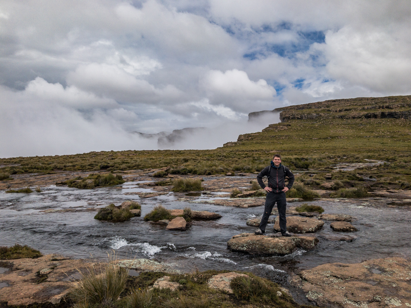
As one of the best hikes on the Drakensberg, the Sentinel Peak Hike has spectacular views along the entire walk. The trail leads up the Mont-aux-Sources plateau, one of the highest mountain ranges of the Drakensberg. This makes it a rather challenging hike.

It’s a return trail starting at the Sentinel Car Park at an altitude of 2500 m (~ 8200 ft). No wonder the views are already spectacular before you’ve arrived at the start of the hike. However, the highlight is at the top of the Tugela Falls.
If you’re into Geocaching, you can search for those couple of caches hidden along this hike. We were short on time though, so didn’t look for any of them.
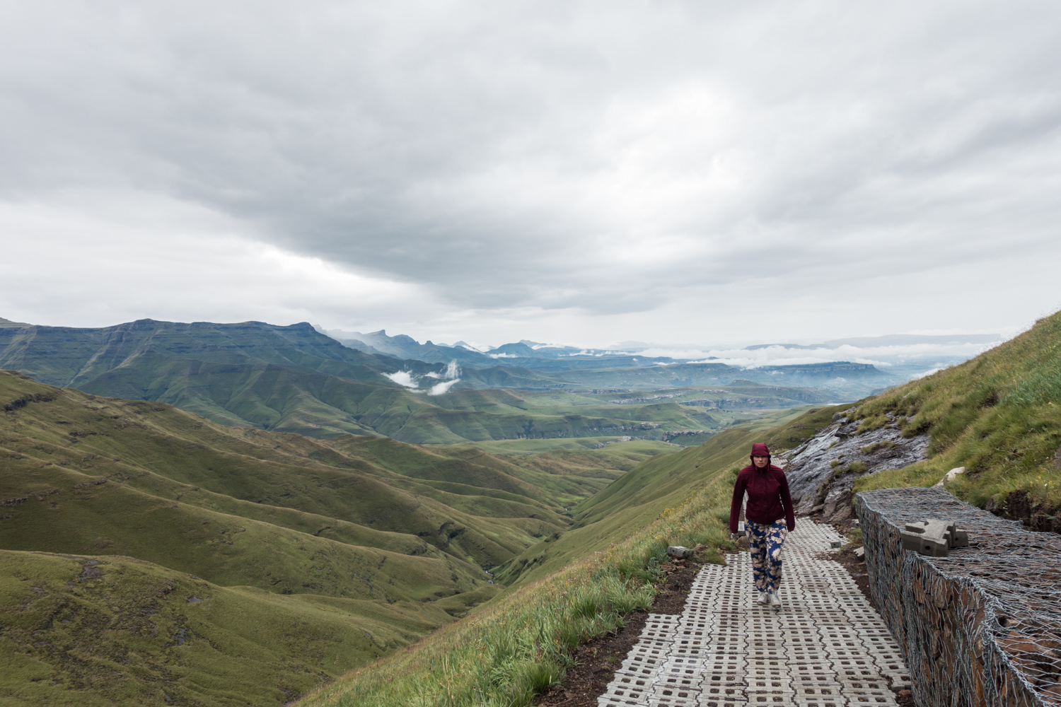
Anyway, start the Sentinel Peak Hike by following the path leading away from the Sentinel Car Park. It will continually climb towards the base of the Sentinel, including some switchbacks.
Near the start of these switchbacks there’s a side path on the left taking you to a viewpoint. There’s a sign pointing you in the right direction, and you’ll know when you’ve reached the viewpoint. We arrived there about 30 minutes after we left the car park.


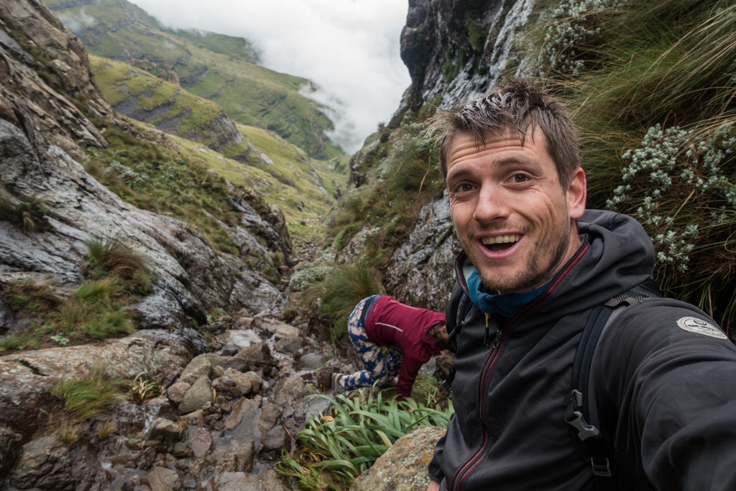
After this short detour, continue on the Sentinel Peak hiking trail. It takes you around the base of the Sentinel Peak before you’ll encounter a rocky section. This part is rather tricky, with a towering cliff on one side and a steep drop on the other.
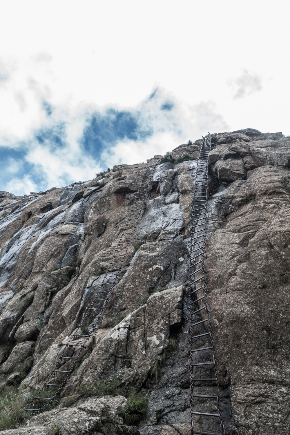
After that, you have 2 options to reach the top of the Mont-aux-Sources plateau: climb up the gully, or up the chain ladders. We decided to go up the gully and down the chain ladders.


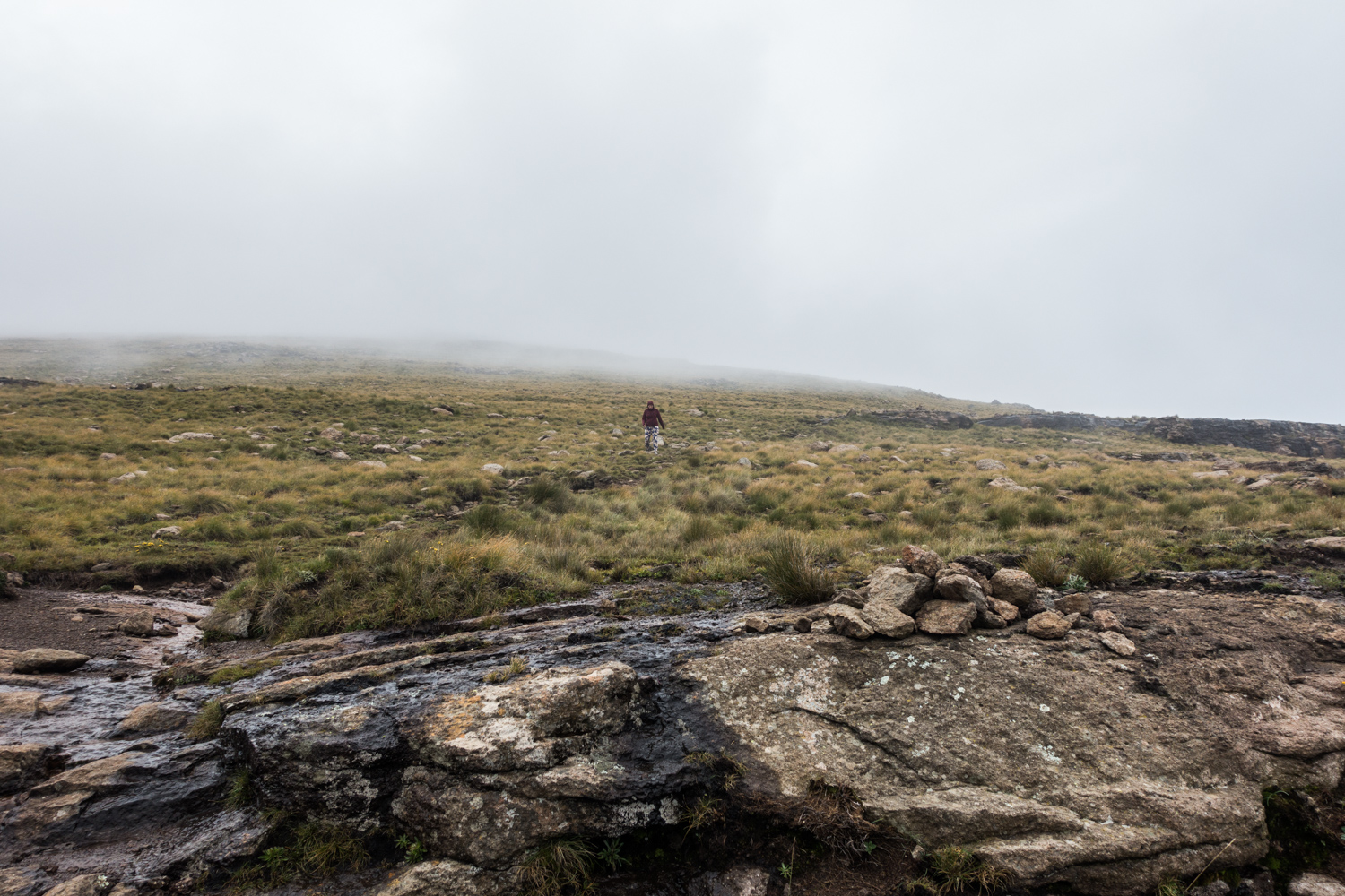
Up the gully
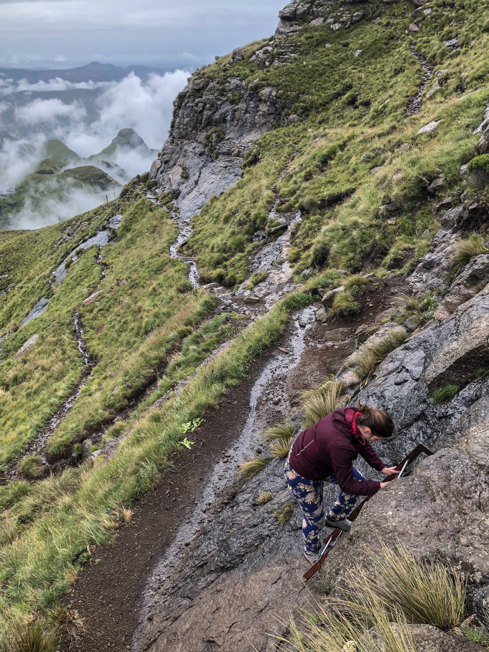
After 2 hours of hiking, we arrived at the bottom of the gully. It’s located between 2 peaks, the Sentinel and Beacon Buttress.
It took us about an hour to reach the top of the gully, climbing over slippery rocks at a 45° angle with water trickling down. Maybe not the best idea in hindsight, but we made it.


Near the end of the climb there’s a fork in the gully. We chose left, so aren’t sure where right would get you.
Once you reach the top, you’ll be rewarded with breathtaking views. You’re now watching Royal Natal Nature Reserve from above. You’ll also see part of the Amphitheatre wall, which you won’t see from the top of the Tugela Falls.
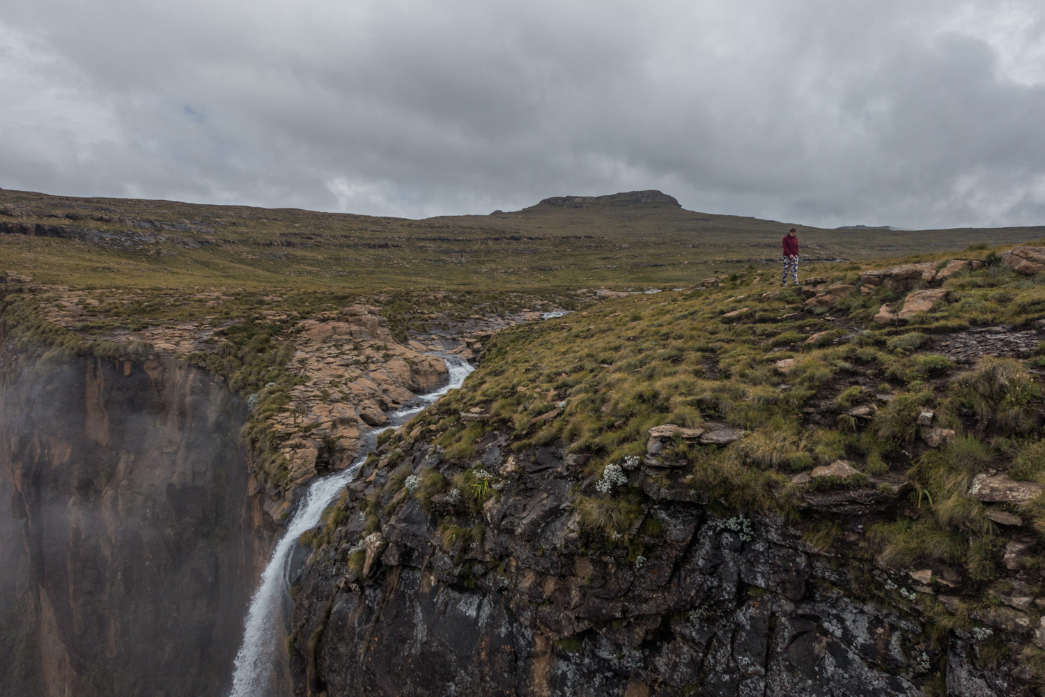
To get to the Tugela Falls, walk along the edge of the Mont-aux-Sources plateau or follow the cairns, the big heaps of rocks. That will take you about another 30 minutes.


We spent about 20 minutes at the Tugela Falls, enjoying the views. We watched the water from the Tugela River dropping down in the Tugela Gorge below and tried different angles to get a good shot of the waterfall. Be careful though, as there are no safety barriers.
You can return to the Sentinel Car Park the way you came, via the gully. This return route is about 8 km (~ 5 miles). Scrambling down those rocks is rather tricky though, so we decided to go down via the famous chain ladders.


Down the chain ladders
The fastest path from the Tugela Falls to the chain ladders follows the Tugela River. When you’re getting near the other edge of the Mont-aux-Sources plateau, the trail bends to the right.
This part of the Tugela Falls Hike takes about 30 minutes. You can walk on either side of the river. On the right you’ll see a ranger’s outpost and you’ll probably encounter some cows as well.
On our way to the chain ladders we had a rather strange experience. A person wearing a blanket, rubber boots and no pants approached us rubbing his belly saying “hungry”. We gave him a candy bar and continued walking.


Not much further another person starting whistling and yelling from a distance to get our attention. We couldn’t make out what he was saying at first, but eventually he asked the time. We left him a bar as well.
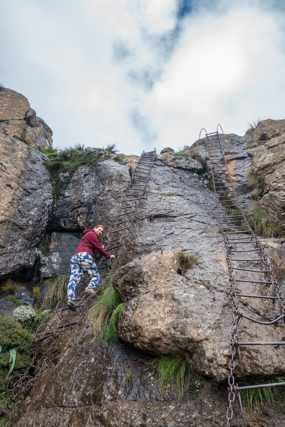
Back to the chain ladders now. There are 2 sets of nearly vertical steel chain ladders of about 50 rungs each. At both sections one of the chain ladders has safety handles, the other doesn’t. Although it’s a tad scary to get over the edge and onto the chain ladders, compared to climbing the gully the descent via the chain ladders was peanuts. Just don’t look down too much.
A third person in a blanket, rubber boots, a balaclava and no pants followed us down the chain ladders. This was making us a bit uneasy, because we were running out of food to hand out. And these were the only people we saw in those 6 hours, no other hikers.
Do look down before you start though, to make sure no one is coming up at the same time.


The guy from our hostel later explained they are part of a Lesotho tribe, known to be making contact with hikers passing there. According to him they are harmless.
Anyway, we headed back towards the Sentinel Car Park and 20 minutes later we were back at the bottom of the gully we climbed earlier.
Another hour and 15 minutes later, we were back at the car park. The workers had already left, but the guy we signed the register with was looking out for us returning. Apparently we were the last hikers out there, and he seemed relieved we were back. Don’t forget to sign out of the hiking register! Wouldn’t want them organising an entire rescue operation while you’re actually in the shower at your hostel.
The return route via the famed chain ladders (no going up or down the gully) is about 14.5 km (~ 9 miles) and probably the safer choice. This hiking trail is sometimes called the Drakensberg Chain Ladder Hike or Walk as well.

Time schedule of us hiking the Sentinel Peak Trail
10:35 start at Sentinel Car Park
11:05 at viewpoint
12:35 at bottom of the gully
13:30 at top of the gully
14:05 at Tugela Falls
14:25 started hiking again
15:05 at bottom of chain ladders
15:25 back at bottom of the gully
16:40 back at Sentinel Car Park
Drakensberg guided hike to Tugela Falls
Some say you should only do the Sentinel Peak Hike accompanied by a guide, but we were just fine on our own. If you prefer a guide, there are a couple of options too though.
Most of these guided hikes to Tugela Falls include transportation to the starting point, park fees, lunch, and a guide obviously.
Amphitheatre Backpackers Lodge, also a popular place to stay near Tugela Falls, offers a bunch of guided hikes. Click here for more information on the Amphitheatre Backpackers guided hike to Tugela Falls.
Witsieshoek Mountain Lodge is another accommodation option offering guided hikes. Find the rates for guides (and packed lunch) from Witsieshoek on their website, together with some information on all hikes in the neighbourhood.

Karma Backpackers is a small hostel working together with guide Zee. You can book a guided hike to Tugela Falls through the Karma Backpackers website. They call it the Amphitheatre Hike.
GoVertical is a South African adventure company offering guided multi-day and day hikes on the Garden Route, near Cape Town and in the Drakensberg. Click here for more information on the GoVertical guided hike to Tugela Falls, which they call the Drakensberg Amphitheatre Hike.
If you’re interested in combining a guided tour of the Sentinel Peak Trail with a home stay, check out this Tugela Falls Hike tour.
These probably aren’t all options for hiking the Sentinel Peak Hike with a guide. If you have experience with another company offering a guided hike to the Tugela Falls, please let us know in the comments!
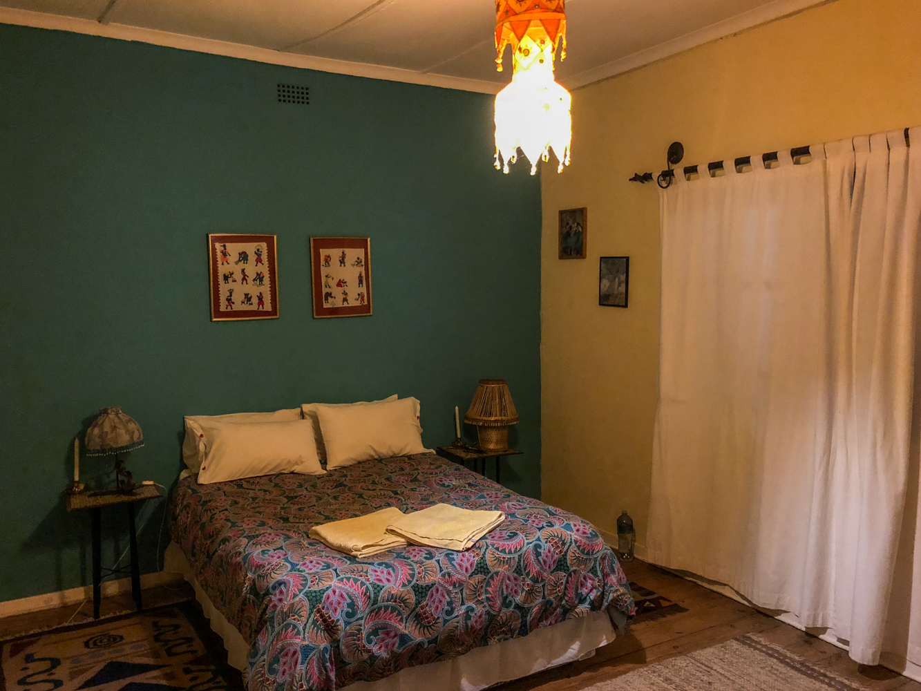
Accommodation near Tugela Falls
Our first choice to stay close to the Sentinel Peak Hike was Amphitheatre Backpackers Lodge. Unfortunately they were fully booked for that particular night, so we went with Karma Backpackers.
Amphitheatre Backpackers Lodge is a very popular budget-friendly accommodation option near the Sentinel Peak Hike. They offer all kinds of activities and guided hikes. From the lodge it’s about a 2 hour drive to the Sentinel Car Park. Check the rates and availability at Amphitheatre Backpackers Lodge here and book well in advance!


Karma Backpackers is a small hostel only about an hour and a half from the Sentinel Car Park. It had a hippie feel to it, with a friendly host eager to provide us with all information needed for the Sentinel Peak Hike and other things to do in the area. Check the budget-friendly rates and availability at Karma Backpackers here.
The accommodation closest to the Tugela Falls Hike is Witsieshoek Mountain Lodge. They offer transfers to the Sentinel Car Park, which is only 25 minutes away, as well as guided hikes and other activities. Prices are mid-range, but you can check the exact rates and availability at Witsieshoek Mountain Lodge or Resort here.
If you’re planning on exploring more of Royal Natal National Park (technically it’s just a Nature Reserve), you can opt to stay at Thendele Camp. It’s located in the reserve, but a 2 hour and 20 minute drive from the Sentinel Car Park. Check the rates and availability for the different accommodation options at Thendele Camp here.
Another option is staying at Tugela Falls Bed & Breakfast, which is situated just outside of the Royal Natal National Park, so a little closer to the Sentinel Car Park (2 hour drive) and way cheaper.
You can also splurge on a cottage with a view on the Amphitheatre at Berghouse and Cottages. From there it’s only a 1 hour and 50 minute drive to the Sentinel Car Park. Check the rates and availability for Berghouse and Cottages here.

The Sentinel Peak Hike is definitely one of the most challenging and rewarding hikes we did so far, together with the Tongariro Alpine Crossing in New Zealand. This awesome hike to the Tugela Falls is not that popular (yet), making it even more remarkable. Even though it’s pretty far from the usual must-sees in most South African itineraries, it’s worth the detour!
Like it? Pin it!
Did you find this post helpful? Help us spread the word by sharing this post or pinning the following image.

This place looks beautiful and remote. We like doing trips like these ones a bit off the path and unknown. Thank you for all the wonderful tips
Hi Camila & Cory, hope you get the chance to do this hike someday! Got any plans to visit South Africa soon?
Hello,
Any recommendation of whether to do the tugela gorge trail instead of the sentinel peak trail?
Hi Mariana,
We’ve only hiked the Tugela Falls Hike, so unfortunately I can’t give you a recommendation based on our experience.
I can tell you that the big difference between both hikes is that the Tugela Falls Hike takes you to the top of the Tugela Falls and the Tugela Gorge Hike takes you to the base of the falls. I’ve read they’re similar in length and difficulty, so I guess it depends on which view you want. You want to see the view from the top of the Amphitheatre or you want to see the Amphitheatre wall tower out above you?
I did find a blog post of someone who’s done both hikes, and she seems to recommend the Tugela Falls Hike. You can read about her experience for yourself here: https://www.jackandjilltravel.com/tugela-gorge-hike/
The hiking conditions on the Tugela Gorge Trail probably depend on the time of the year and the weather on the day of your visit and the days beforehand as well. So I’d suggest: read up on both hikes beforehand and ask for (expert) advice of locals in your accommodation!
Hope this helps! Let me know if you have other questions or want to know more about other things to do in South Africa.
Enjoy your trip!
Birthe
Hi Birthe, thanks! This information is really useful.
This is the best and most informative review i have read. Well done!
Thanks, Sidney! Good to hear you found it helpful. 🙂
I did this about ten years ago – this article is beyond excellent! I am on my way back – will do it again. Thanks so much! Loved this
Thanks for the compliment, Yvette! Enjoy the hike and if you have the time, feel free to let us know how it went. It’s been a couple of years since we were there and maybe not everything is up to date anymore. 🙂
Can I do the Tugela falls trail on my own?
Honestly, I wouldn’t have felt safe doing the hike alone. But there are plenty of guides available to do the hike with you. Another option is to ask around at your accommodation for others wanting to join you for the hike. Most people that stay in the neighbourhood are there solely for that purpose anyway. 🙂
any idea what is the length and elevation through the gully
It took us about an hour from the bottom to the top of the gully, climbing over slippery rocks at a 45° angle with water trickling down. Not sure what the distance or elevation is. Hope this helps?